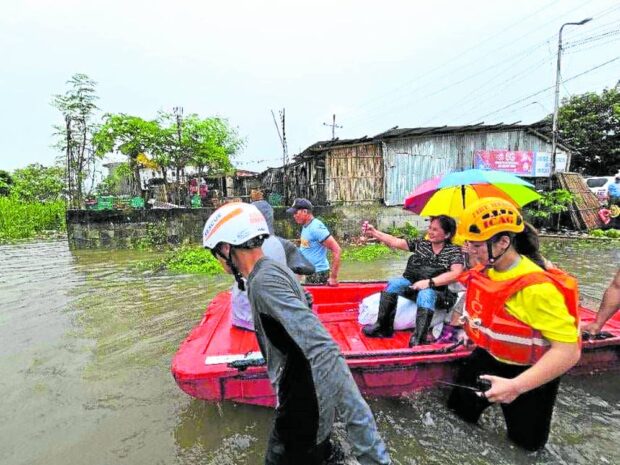
Goring worst to hit Iloilo City since 2008
ENSURING SAFETY | Policemen and emergency responders, in this photo taken on Tuesday, help evacuate residents of Barangay Sooc in Arevalo district as floods hit a large part of Iloilo City. (Photo from the Iloilo City CDRRMO-Urban Search and Rescue)
ILOILO CITY, Iloilo, Philippines — Floodwaters about a meter high greeted residents here at the beginning of the week due to heavy rains accompanying Typhoon Goring (international name: Saola).
According to the City Disaster Risk Reduction and Management Office (CDRRMO), 90 of 180 barangays in the city remained flooded as of Wednesday. These include 24 in Jaro district, 16 in Mandurriao district, 13 in City Proper, 10 each in La Paz and Molo districts, and five in Lapuz.
The highest flood levels reached 38 inches, or almost a meter, which were logged in the Barangay Cuartero on Monday and Camalig village on Tuesday.
The city logged a total rainfall volume of 356 millimeters from Aug. 1 to Aug. 30, with 256 mm attributed to Goring.
A total of 6,072 families (23,260 people) from 58 barangays were reported to have been affected as of 8 a.m. on Wednesday, with 16,751 people from 47 villages forced to evacuate.
In a statement, Mayor Jerry Treñas described Goring as the “most severe” to hit the city since Typhoon Frank (Fengshen) in June 2008.
“More than 12,000 [people] were at the evacuation centers as of 12 noon [on Aug. 29]. I thank the [City Social Welfare and Development Office] for making sure everyone had enough food. I also thank all Ilonggos who contributed food … for the evacuees,” he said.
Treñas on Wednesday asked representatives from the Department of Public Works and Highways (DPWH), the Department of Environment and Natural Resources, the government weather bureau, the academic community, and experts in other fields to sit down with local governments in Iloilo province to discuss the recent flooding.
“For the first time in Iloilo City, areas which were not previously flooded experienced intense flooding. We should study the situation seriously so that we can prevent similar occurrences in the future. Projects of the DPWH in the future should be able to prevent the same to preclude damage to property and worst, loss of lives,” the mayor said.
“On our part, we need to intensify our efforts for tree planting, conversion to renewable energy, bigger drainage systems, more pumping stations, more cisterns, more rainwater harvesting facilities, and other measures,” he added.
Meanwhile, the Bureau of Fire Protection stationed in the southern Iloilo town of San Joaquin advised against the use of the Antique-Iloilo Mountain Road connecting to Hamtic town in Antique after a typhoon-related landslide was reported in the area on Aug. 28.
Situation in Negros
A Philippine Information Agency advisory asked travelers to use instead the Antique-Iloilo Coastal Road connecting San Joaquin to Anini-y, Antique.
In Negros Occidental, the provincial government said typhoon-related losses in agriculture, fisheries and livestock in the province and Bacolod City reached at least P115 million.
Reports from the Provincial Disaster Risk Reduction and Management Council said 25,709 families (82,594 people) were affected by flooding in 10 towns and six cities in Negros Occidental as of 5 p.m. Tuesday.
Among the areas hit by heavy rain and floods were the cities of Bago, Himamaylan, Silay, San Carlos, Valladolid, La Carlota, Binalbagan and Talisay; and the towns of Pulupandan, San Enrique, Pontevedra, Murcia, Hinigaran, Isabela, La Castellana and EB Magalona.
Classes in 26 Negros Occidental localities and work in government offices in 14 towns and cities were suspended on Tuesday.
Joe Recalex Alingasa Jr., disaster risk reduction and management officer of San Carlos City, advised motorists using Eco Translink Highway to be on alert as their initial assessment and monitoring of the upper portion of this road showed there were signs of an active landslide or rockslide caused by high saturation of water along its steep slopes.
Two landslides were also reported in Don Salvador Benedicto town.
In Bacolod City, at least 31 villages were hit by floods, affecting 2,644 families (8,642 people). Reports said at least 6,781 residents were staying in evacuation centers.


